
File:Map German SpeakingWorld.png

Size of this preview: 800 × 370 pixels. Other resolutions: 320 × 148 pixels | 640 × 296 pixels | 1,357 × 628 pixels.
Original file (1,357 × 628 pixels, file size: 36 KB, MIME type: image/png)

|
File:Legal statuses of German in the world.svg is a vector version of this file. It should be used in place of this PNG file when not inferior.
File:Map German SpeakingWorld.png → File:Legal statuses of German in the world.svg
For more information, see Help:SVG. |
 |
| Description |
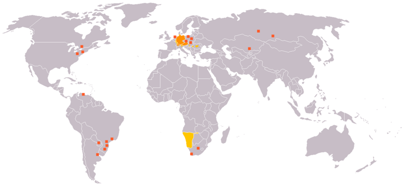
English: Legend:
Deutsch: Legende:
Français : Carte du monde où on parle l'allemand.
עברית:
Italiano: Legenda:
Nederlands: Beschrijving:
Svenska: Beskrivning:
|
||||||||
| Source | en:Image:Map_German_World.png | ||||||||
| Author | en:User:Ilario. | ||||||||
| Permission (Reusing this file) |
I, the copyright holder of this work, hereby publish it under the following licenses:
You may select the license of your choice. |
||||||||
| Other versions | File is obsolete! Use File:Legal statuses of German in the world.svg instead. |

File history
Click on a date/time to view the file as it appeared at that time.
| Letsatsi/Nako | Thumbnail | Dimensions | Mosebelisi | Comment | |
|---|---|---|---|---|---|
| current | 20:35, 18 Phupu 2020 | | 1,357 × 628 (36 KB) | Maphobbyist | South Sudan and Montenegro borders |
| 09:14, 11 Pudungwana 2007 |  | 1,357 × 628 (46 KB) | Domaleixo | ||
| 18:28, 27 Phupu 2006 |  | 1,357 × 628 (25 KB) | Cwlq~commonswiki | ||
| 06:18, 28 Phupjane 2006 |  | 1,357 × 628 (37 KB) | Highpriority | {{Information |Description=en: Legend: *Orange: native language *Gold: Secondary language or non-official. *Red-orange square: German minorities de: Legende: *dunkles Orange: Amtssprache/Muttersprache *helles Orange: Zweitsprache oder nicht offiziel |
Tšebeliso ea faele
There are no pages that use this file.
Global file usage
The following other wikis use this file:
- Tšebeliso ho de.wikipedia.org
- Tšebeliso ho fr.wikipedia.org
- Tšebeliso ho incubator.wikimedia.org